Converting EPANET Entities to Geospatial 3D Models
EPANET Positioning vs Google Maps/Tiles
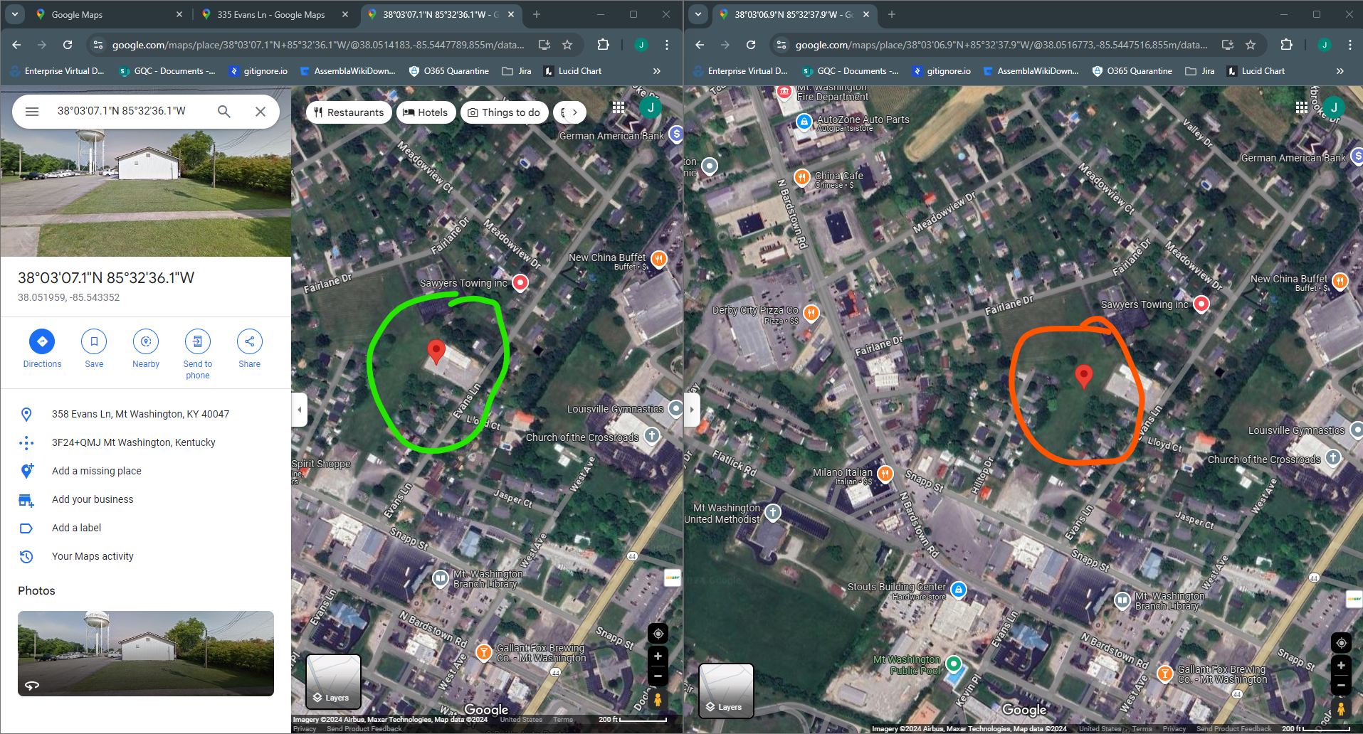
Tank T-3 is pretty far off from where it looks like it should be.
In the following image, the tank position according to Google is on the left and circled in green. The tank position according to the INP file is on the right and circled in orange.
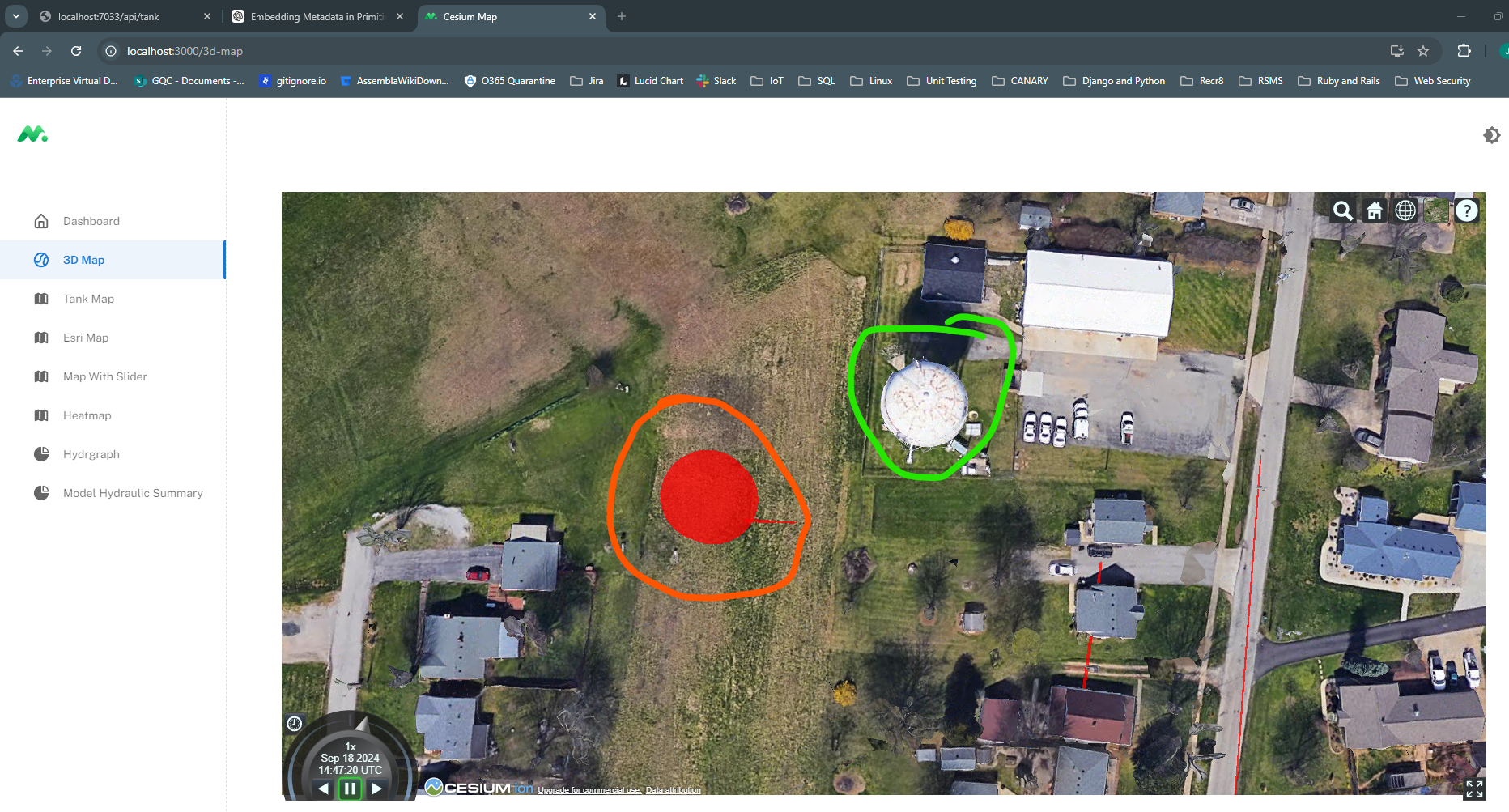
The next image shows the 3D representation where you can easily compare the EPANET location vs Google Tiles:
Using Metadata from Model (gltf) in Cesium
It's not supported by default, but we might be able to hack it.
want-to-see-extra-attributes-on-model
This one is very informative!
best-practices-for-tileset-and-gltf-structure-and-embedding-metadata
They talk about the MetadataGranularities Example.
This guy is highlight-able and clickable
Subsurface Rendering in Cesium
https://sandcastle.cesium.com/?src=Globe%20Translucency.html
Placing Objects on Globe
https://community.cesium.com/t/correctly-positioning-coordinates-from-imported-gltf-file/32583
https://cesium.com/learn/unity/unity-placing-objects/
Notes
P-363
{"scene": 0, "scenes": [{"nodes": [0]}], "asset": {"version": "2.0", "generator": "https://github.com/mikedh/trimesh"}, "accessors": [{"componentType": 5125, "type": "SCALAR", "bufferView": 0, "count": 384, "max": [65], "min": [0]}, {"componentType": 5126, "type": "VEC3", "byteOffset": 0, "bufferView": 1, "count": 66, "max": [-85.05097961425781, 38.19375991821289, 166.3557586669922], "min": [-85.16287994384766, 38.089717864990234, 163.24940490722656]}, {"componentType": 5126, "count": 66, "type": "VEC3", "byteOffset": 0, "bufferView": 2, "max": [0.7301567792892456, 0.7284263372421265, 0.9999942183494568], "min": [-0.7301567792892456, -0.7284263372421265, -0.9999942183494568]}], "meshes": [{"name": "geometry_0", "extras": {"id": "P-363", "diameter": 4, "length": 3099.239, "roughness": 150, "minorLoss": 0, "kWall": 0, "fromNode": "J-510", "toNode": "J-513", "coordinates": [[-85.6580041, 38.0110893, 162.99646344], [-85.6477072, 38.0135305, 166.10246688]]}, "primitives": [{"attributes": {"POSITION": 1, "NORMAL": 2}, "indices": 0, "mode": 4}]}], "nodes": [{"name": "world", "children": [1]}, {"name": "geometry_0", "mesh": 0}], "buffers": [{"uri": "gltf_buffer_0.bin", "byteLength": 1536}, {"uri": "gltf_buffer_1.bin", "byteLength": 792}, {"uri": "gltf_buffer_2.bin", "byteLength": 792}], "bufferViews": [{"buffer": 0, "byteOffset": 0, "byteLength": 1536}, {"buffer": 1, "byteOffset": 0, "byteLength": 792}, {"buffer": 2, "byteOffset": 0, "byteLength": 792}], "extensionsUsed": ["CESIUM_RTC"], "extensions": {"CESIUM_RTC": {"center": [-85.65285564999999, 38.012309900000005, 164.54946516]}}}
In state plane:
{ "type": "Feature", "properties": { "id": "P-366", "diameter": 4, "length": 531.869, "roughness": 150, "minorLoss": 0, "kWall": 0, "index": 0, "fromNode": "J-406", "toNode": "J-516" }, "geometry": { "type": "LineString", "coordinates": [ [ 1508732.829827583394945, 1187181.029609422665089, 165.25670784 ], [ 1508759.191200410714373, 1187021.614262490533292, 168.02240208 ] ] } },
It looks like the closest match was when I assigned lat/long as the from node and scaling to 0.1. However, the length is WAY off, as is the orientation. Playing with the rotation (heading, pitch, roll) didn't help much...
I'm going to try re-exporting them in EPSG:3088, Kentucky Single Zone. I think this will help with pipe length and layout.
Maybe then we can define the starting point of the whole network as min/max of the KY ref system, i.e. (0,0) in EPSG:3088 should correspond to some lat/long in WGS84?